About
Type: Extant
Parish: St.Philip
Founding date: 1740
See on Google Maps!
Current Status
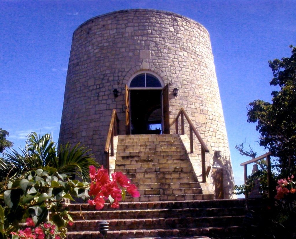
This estate is now part of Mill Reef and runs along the seafront In its day this estate also raised cattle and ground provisions. The mill on this site is not the original but was reconstructed supposedly near the original mill site with stones taken from one of the mills at Long Lane, while Sheriff’s mill at the entrance to Mill Reef is the mill that gives the club it’s logo.
Estate Related History/Timeline
1740: James Watson, planter (bapt 1740-1799)
1741: “The key stone above the main arch bears the following inscription” “K.B.M./1741”.
As the key stone originated from Long Lane Estate, this could be Benjamin M. King who owned the property in the 1750’s. The 1777/78 Luffman map shows a “Hamiltons” in this area, owned by Brinton & Rigg.
1829: In 1829 this estate contained 460 acres and had 55 slaves.
1851: The Antigua Almanac shows Watson’s of 460 acres belonging to Francis Watson.
1852: This estate contained 460 acres. Francis Watson also owned the Hope plantation of 208 acres.
Vere Oliver Vol.III p.208
1866: James Watson Sheriff had inherited considerable property in Antigua.
Vere Oliver Vol.III p.85
See Sherriff’s (#125 for History of Mill Reef.)
1969: The original mill was destroyed but the owners of the Watson property at Mill Reef purchased and rebuilt a mill in the vicinity of the original mill. The mill was dismantled at Long Lane (there is still a second mill at Long Lane) using the outer cut stone c.1969 in order to obtain the correct angle.
The remains of the internal rubble and inner wall still exist in the bush at Long Lane. This work was carried out by Samuel Mayer of Freetown who met with me to identify the original site at Long Lane which still contains the rubble used to pack in-between the outer and inner worked stone walls. Each stone was carefully numbered to aid in reconstruction and rebuilt near to the site of the original Watson’s mill.
In order to protect against earthquake damage in the future a metal framework cage was constructed within the thick walls. The actual mill building is considerably larger and taller than the original in order to provide comfortable living quarters. The bedrooms are on the lower floor extension with outside access to the living room. A magnificent 4’ Bohemian crystal chandelier hangs from the ceiling making this room with its panoramic sea view, most unique.
Enslaved People’s History
Based on contemporary research, we have little information to share about the enslaved peoples from this plantation at this time. We only know that Watson’s was awarded £502 4 s 11 d for the liberation of 40 enslaved peoples after slavery was abolished in the Caribbean. Warwick Pearson Hyndman and Francis Watson were awardees. Unsuccessful were John Cunningham the younger, John Cunningham, Ref. Sir Augustus Bridges Hermicker 3rd Bart, John Jameson and James Watson Roberts. James Watson was listed as previous owner and Thomas Watson as Beneficiary deceased. Not claimants but listed were John Elliott Hyndman, Robert Hyndman and William Jenkins. Also, Watson’s was awarded £391 6s 2d – both claims largely share the same claimants and counter-claimants. However, we will continue our quest for more information about these vital individuals.
Ownership Chronology
Ownership from 1740 Nicholas Power
- 1750: Robert Watson (d.1754)
- 1790: James Watson (bapt.1740-1799)
- 1800: James Watson
- 1829: Francis Watson – 400 acres, 55 slaves
- 1852: Francis Watson – 460 acres 1851 Antigua Almanac
- 1866: James Watson Sheriff – Also owned Sherriff’s (#125)
- 1872: T.T. Sword & T.D. Aitkin – 370 acres 1872 Antigua Horsford Almanac.
- 1878: Richard Taylor Esq. of Swords
- 1933: Virginia Shoy 1933 Camacho map
- 1948: Mill Reef
- 1950: Hicks Kerr mill site
- 1959: Watson mill site
- 1962: Fred Olson mill site
- 1991: B.B. Ryder mill site