About
Type: Extant
Parish: St.Paul
Founding date: 1740
See on Google Maps!
Current Status
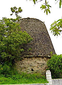
This mill is now completely surrounded by the village of Liberta and can be found behind and up the hill to the west of St. Barnabas’ Church.
Reference is made to ‘Freeman’s Rest’ of 300 acres in St. Paul’s Parish. This could be Buckshorne’s.
Estate Related History/Timeline
1734: Capt. Paul Horsford of Falmouth sells 61a. 3r. 17p to Dr. Buckshorne, planter surveyed.
1743: Joseph Buckshorn, jun, petitions for £124, his salary as deputy-storekeeper at Great George Fort.
1787: In 1787 Buckshorne’s Plantation contained 250 acres. Bounded in the north by Tankard’s, east by Gale, south by Horsford and west by Kirby.
1815: “Sir John Tyrrell …. and Charles Cheshire of Antigua absolutely in fee simple a piece of land in the Parish of St. Paul and division of Falmouth called “Buckhornes”, and formerly cultivated as a sugar plantation, contained 200 acres bounded N. with land by Adm. Richard Tyrell dec., E. by land late of Capt. Grant Gordon but now of Margaret Harcum, S. by lands of the said Samuel Athill and W. by the lands of the late William Maxwell, and all buildings, etc. thereon, and also three negroes, for the sum of 1,500 pounds, to be paid in full …..” Vere Oliver Vol.III p.120
1851: The Antigua Almanac shows Buchshorne’s of 200 acres belonging to Heirs of Mrs. Gilchrist.
The Birth of the Village of Liberta by Hewlester A. Samuel, Sr. Dr. Buckshorne’s son, Joseph, was at one time, the deputy store keeper at Great Fort George. On 1743 September 22nd, he petitioned the government for his salary as deputy storekeeper. Less than a year later, he and his father died. Barry Buckhorne continued to manage the estate after their deaths.
When the Willises sold the estate to Sir John Tyrrell, Buckshorne automatically became part of the Tyrrell Estate.
Prior to John Tyrrell’s purchase of the estate from the Willises, they controlled the estate in absentia since inheriting from the Buckshornes, Freemans and the Willises. After the lease expired they sold it to the Cheshires. The Cheshires did not keep the estate for any length of time before selling it to the Gilchrists. The Gilchrists, like most of the previous owners, found that it was not economically feasible to operate the estate as a sugar plantation and sold it to Domingo Techeira. The estate stayed in the hands of the Techeiras for almost one hundred years, then in the 1940’s and 1950’s, Mr. Norman Techeira decided to sell the estate in parcels to tenants or anyone interested; hence, the estate was no longer a sugar-producing plantation, but a residential neighborhood. It became one of the most populous areas of the village.
The boundaries of Buckhorne’s today are different from its original boundaries described in the original bill of sale. Buckshorn starts at the entrance of the northern end of the village and winds along the west side of the Liberta Main Road until Bridge Gut. Richmond Estate and part of Howard’s estate bound it on the west. To the south is Barrell Beef and to the north is Tyrrell, and east is Table Hill Gordon. One of the deepest gullies in the area is on the southern side of the estate. The soil in this valley is very rich because it is surrounded by hills on all sides and is the recipient of the water that runs off these hills into the valleys.
Anyone who knows the village will not forget Mount Williams Bluff, which was the great house for the estate where the overseer used to live. When the estate went out of sugar production there were no great need for the whole great house, so it was divided into two sections; one was used to house the resident owner and his family, the other was used to rent for entertainment purposes until it went out of business.
This section of Buckshorn still has the base of one of the old windmills used on the estate when it was in the sugar production business. It can be seen as you travel on the east-west road on Buckshorn, known as Quarry Hill.
Another point of interest at Buckshorn is the Quarry Hill area if you are interested in the geology of the village. It is home to vast amounts of green limestone which is indigenous to the island.
Of the many slaves on Buckshorne’s plantation, one was so rebellious and violent that his master ordered one of his legs amputated (Gasper 202-204).
1941: Antigua Sugar Factory, Ltd. Cane Returns for 1941 Crop. Buckshorne. Estimated 210 tons, 18 acres peasants on the estate, tons of cane delivered 222.
Enslaved People’s History
Based on contemporary research, we have little information to share about the enslaved peoples from this plantation at this time. We will continue our quest for more information about these vital individuals.
Ownership Chronology
Ownership prior to 1740 Dr. Buckshorne (d.1744)
- 1746: Mary Buckshorne
- 1759’s: Mary Freeman Willis – 1777/78 Luffman map
- 1790: Mr. Oliver (leasehold)
- 1800: Sir John Tyrrell
- 1815: Charles Cheshire
- 1851: Heirs of Mrs. Gilchrist
- 1870: Gilchrists
- 1878: Domingo Tachiera
- 1933: Norman Tacheira
- 1940: Manny Tachiera (Portugee Manny)