About
Type: Ruin?
Parish: St.Philip
Founding date: 1750
Long, lat: ?, ?
Current Status:
Christian Hill is always referred to in the same context as Bethesda. They are synonymous. Joy Lawrence has written a book on the village of Christian Hill and Bethesda and just recently the Precision Centre showed their historical rendering of the same at the 2016 Independence celebrations. The latter is all about preserving the stories of old as remembered by the elders in the village, some of which were passed down.
Estate Related History/ Timeline
Water was and is always a major concern and prior to standpipes in the village it was a daily trip to one of the nearby ponds to collect a bucket or kerosene can of water which was carted back by balancing on their heads. There was a spring nearby and one of the ponds in the area was east of Blake’s estates which was kept clean for human consumption. The people respected this and would not carry their animals to drink from this pond or foul up the water. There was a day for washing clothes when the women gathered at the water source – some took in washing to supplement their income. In the old days besides the regular carbolic soap there was a clay that was used to rub and clean the khaki and dungarene (dungaree) pants and even when used on white shirts, the whites came out bright, bright.
They mentioned the horse races particularly on Whit Monday that was a source of pleasure for everyone. One particular day the chain for the horse wrapped around a lady’s foot and dragged her all over the village, however, she survived. The pasture where everyone gathered to play cricket was referred to as Number Seven, because that was the number of the cane field in the day. Bethesda is very proud of three sons of the soil who went on to play for the West Indies cricket team – Devon Thomas, Gavin Tonge and Martin.
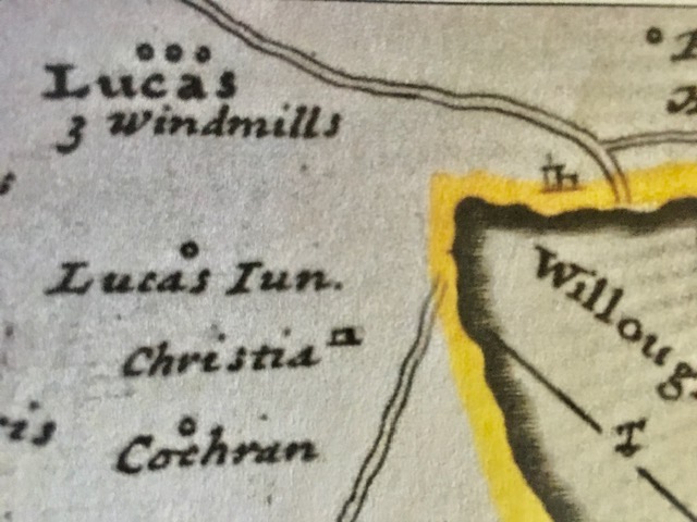
As you drive from Bethesda around Willoughby Bay towards Falmouth, you pass a small park on the headland named Red Hill Park. The 1787/88 Luffman map shows the area known as Red Hill.
“Mathew Christian (d.1779) heir to uncle Mathew (d.1758) Red Hill 410 acres, Bevans 200 acres, The Valley 350 acres, Huyghues of 200 acres, Elmes of 149 and 180 acres.” Vere Oliver Vol.I p.135
George W. Ottley and Jane his wife of Parham Hill had nine children all of which were baptized in St. Peter’s Church in Parham. The Tudway family were absentee landowners and had a succession of overseers who lived on the property.
1941 – Antigua Sugar Factory Ltd Cane Returns for 1941 Crop. Red Hill. Estimated 1000 tons – acres estate – acres peasants on the estate, tons of cane delivered 791.
1958 The Syndicate Estate sold 16 acres of land to Government for a school, playground and village extension.
One of the North Sound Islands is called Redhead, and in 2014 there was a petition to make
Rabbit and Redhead a nature reserve. In 2015 both islands became part of the Chinese Yedo deal in conjunction with Guiana Island, Coconut Hall and Hawes.
Enslaved People’s History
Based on contemporary research, we have little information to share about the enslaved peoples from this plantation at this time. We will continue our quest for more information about these vital individuals.
Ownership Chronology
- 1750 Mathew Christian. d.1779. 410 acres.
- 1851 & 1872 none of these names appear in the Antigua Horsford Almanac. Neither in the History of the Island of Antigua by Vere Oliver. Vol.III P.390 which lists estates and owners from the 1700’s to late 1800’s.
- 1933 Government Land Settlement Red Hill. 1933 Camacho Map.
- 1941 Sugar cane returns to ASF for Red Hill 791 tons.
- 1958 Antigua Sugar Factory Ltd.
- 1968 Antigua Government – Crown Land.