About
Type: Ruin
Parish: St.Peter
Founding date: 1668
See on Google Maps!
Current Status
There is no longer a mill at this site and this estate later converted to steam. Any evidence of the former estate has probably been eliminated with the US Navy Base installation during WWII. In fact, large concrete slabs still attest to the US occupation, and I remember as a child attending a birthday party on one of those slabs near Umbrella Point beneath the Casuarina trees. We were near the sea, but it was not good swimming – actually an odd place to hold such a function. Crabbs Peninsular contains the east side of Parham harbour making it particularly safe for shipping and it was because of this that the town of Parham was formed. The 1727 Herman Moll map shows the peninsular named North Sound Pt. with a Meynell owning an estate just east of Parham town. It was originally thought that Parham would be the capital city of Antigua, but St John’s took precedent.
The Desalinization Plant, APUA Electric Power Station, the Cement Plant and the Antigua Brewery are also at Crabbs. Crabbs Marina, which is still located on many maritime maps, no longer exists and this piece of land, approximately nine acres, was eventually purchased by Allan Stanford and turned into a first class docking area taking advantage of the original dredging from the 1940’s. 2014 this area has now been turned back into a marina, boat storage and repair.
Not sure when this happened but it was definitely early days as far as Antigua settlement was concerned. A very graphic depiction of a scene that occurred at the Crabb’s Great House. “At the great house at Crabbs, a Grand Ball was in full swing. Elegant ladies fluttered and fanned, dashing young blades postured and bowed, chaperones glared, flunkeys flunked, and the string quartet was in the middle of a gavotte when with a blood thirsty scream and a crash of breaking glass the Caribs attacked. Within 15 minutes, not a man, woman, or child was left alive….. only the eerie echoes of the slaughtered “fiddlers of Crabbs” could still be heard. As they can be heard from time to time to this day.”
Estate Related History/Timeline
1693: Laurence Crabb 300 acres.
In 1699, it consisted of 360 acres when Laurence and Sarah Crabb conveyed to the Lasher in trust.
1699: Lawrence and Sarah Crabb convey to Thomas Lasher the estate of Crabb’s in trust. In 1702: Crabb was Chief Justice for Falmouth and in 1707 he was appointed to the Council.
1702: Laurence Crabb was Chief Justice for Falmouth and in 1707 he was appointed to the Council. By 1750, Crabb’s was owned by Valentine Morris.
In 1772, this estate contained 550 acres.
1727: children of Lawrence Crabb mortgage to Valentine Morris, Esq., dec., Crabb’s estate in Old North Sound Division and St. Peter’s Parish. By 1734 Isaac, George and William Crabb release to Valentine Morris the equity of redemption.
1743: Will of Valentine Morris. “Ashton Warner & John Frye two plantations in New Division, Parish of St. Mary …… also a plantation in Five Islands. All my plantations in Antigua to my son Valentine Morris and his heirs and then to my daughters.”
1748: Valentine Morris died in 1748 and owned Crabb’s and Willoughby Bay. Vere Oliver Vol.II p.272
1749: Indenture 1749. “ Valentine Morris did covenant, etc….. to set over Crabb’s plantation, etc., and that other one containing 126 acres ….. leased to James Gorden.” (Gowan). Vere Oliver Vol.II p.273
Valentine Morris inherited a large fortune from his father which he dissipated extravagantly ending in debt. In 1772, he became Lieut-Governor of St. Vincent where he became Governor four years later.
1767: By deed dated 1 April, 1767 James Gordon, Esq., purchased of Valentine Morris the two estates in Antigua called Crabbs of 400 and Martins of 126 acres for 11,500 pounds sterling.” V. Oliver Vol.II p.27
The appraisement of Crabb’s in 1777 –
108 slaves worth £5,280, the livestock 1,564 and the new negroes £1,063.
77 acres at 60 pounds per acre £4,620
61 acres at 40 pounds per acre £2,440
120 acres at 20 pounds per acre £2,400
142 acres at 10 pounds per acre £1,420
400 acres £10,880
Total value £25,020.
“NB – a capital mistake herein for considerably above 100 acres are here omitted, the Estate consisting of and above 500 acres, say about 520 instead of only 400 as here estimated at.” V.Oliver Vol.II p.278
Rev. James Coull, owner of Crabb’s (237 acres) owned 899 slaves. Rector of St. Peter and St. George, Antigua from 1809-1828. Arrived in Antigua in 1773 from Scotland which he left to avoid being implicated in the rising of Charles Edward The Pretender. Another brother can be traced to St Vincent and St. Lucia (Roseau estate). The Coull family can be traced back to Banff, Scotland and the Coull castle ruins are well known. William Anne Coull (b.1823) sold Crabbs, the family estate which is listed as Westwood estate in Antigua valued at £7,000. A letter on the Coull family history in Vere Oliver, states that “Thomas Coull, M.D. (my father) sold both estates in St. Vincent and St. Lucia to pay debts on Crabb’s.”
There is a letter from the collection of papers relating to captured negroes from Rev. James Coull dated Antigua, April 28th, 1824, in which he gives a report on baptizing “African Apprentices.” He asks that they have some knowledge of the Ten Commandments of God and the Apostles Creed and has only been able to baptize one adult female and two children. He found that the adults still had an adherence to their African superstitions and found the concept of a God of Mercy instead of a God of Terror, difficult to understand.
In 1821, Rev. James Coull paid the year’s highest price for freeing a female slave, £165 for Isabella Thomas.
In 1818, when owned by James Coull contained 237 acres.
He was the Rector of St. George’s. and left Banff, Scotland from being implicated in the rising for Charles Edward, The Pretender. Two other brothers went to St. Vincent and St. Lucia. Both estates there were sold to pay the debts on Crabb’s.” V.Oliver Vol.I p.178.
1851: The Antigua Almanac shows Crabb’s of 400 acres owned by Thomas Coull, M.D..
1852: 400 acres owned by Thomas Coull, M.D. purchased by Mr. Tudway. No sugar cane is now grown there, the land not being good. Vere Oliver Vol.I p.181
In 1842, this estate contained 400 acres—273 slaves.
1891: an extract from letter by Francis Coull, “Total of cane pieces 237 acres. Plan amongst C.C. Tudway papers the present owner of Crabbs. Both St Lucia (Roseau) and St. Vincent estates were sold by Thomas Coull, MD (my Father) to pay the debts on Crabbs.”
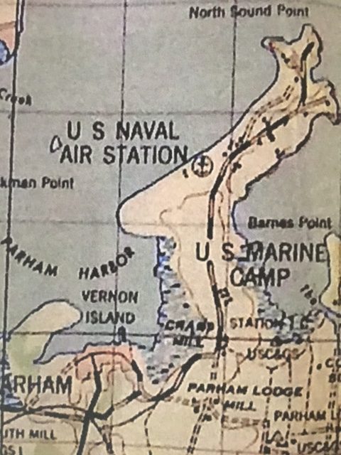
1940’s: In the early 1940’s, this area was leased for 99 years to the US Military during WWII and was designated a Navy Station with housing for the US Marine Corps and US Coast Guards. The Naval Air Station was built at Crabbs with work starting on March 17th 1941 on land acquired from independent peasants, completed by 1943 and closed by 1945. A photograph shows raising of the US flag at US Navy Base by US Marines. (Ctsy. of Vernon Hall) A channel was dredged passing Maiden Island on the south side to facilitate shipping. Most of the dredged material was dumped on Maiden Island turning what were two small islands into one and Shell Beach was born with all of the shells that were washed up on shore across the way.
1977: In 1977, Gerald Bull, who owned a Canadian/American company called Space Research Corporation, tested his High Altitude Research Project (HARP) later known as the Supergun, or Long Gun, in this area. This weapon later showed up in S. Africa (Botha) and in Iraq in 1980. Gerald Bull was eventually assassinated in Brussels.
The peninsular later became the training and exercise area for the Antigua & Barbuda Defense Force and a manufacturing and industrial area. APUA desalinization plant, power plant, the brewery, a boat yard etc…. are all located at Crabb’s. The east coast of Crabb’s is part of the Chinese Guyana Island, Coconut Hall deal to develop this area and in 2016 work started with road building through the bush along the coast, connecting Crabb’s to the above mentioned area.
Enslaved People’s History
Based on contemporary research, we have little information to share about the enslaved peoples from this plantation at this time. We do have this list appraising Crabb’s from 1777:
“108 slaves worth £5,280, the livestock 1,564 and the new negroes £1,063.
77 acres at 60 pounds per acre £4,620
61 acres at 40 pounds per acre £2,440
120 acres at 20 pounds per acre £2,400
142 acres at 10 pounds per acre £1,420
400 acres £10,880
Total value £25,020.”
We also know that “there is a letter from the collection of papers relating to captured negroes from Rev. James Coull dated Antigua, April 28th, 1824, in which he gives a report on baptizing “African Apprentices.” He asks that they have some knowledge of the Ten Commandments of God and the Apostles Creed and has only been able to baptize one adult female and two children. He found that the adults still had an adherence to their African superstitions and found the concept of a God of Mercy instead of a God of Terror, difficult to understand.” Finally, we know that the estate contained 273 enslaved people across 400 acres in 1842 and was later awarded £2,539 7 s 6 d for the liberation of 170 enslaved people. We will continue our quest for more information about these vital individuals.
Legacies of British Slave-ownership:
Antigua 321 Crabb’s Estate was awarded £2,539 7 s 6 d for 170 enslaved.
William Shand was the awardee.
Ownership Chronology
- 1668: Hon. Lawrence Crabb, Esq. mortgaged to Valentine Morris
- 1727: Valentine Morris Esq.
- 1750: Valentine Morris (1727-1789)
- 1767: James Gordon (Gowan) Esq.(arr. Anu.1741) for £11,500
- 1777/78 Harts? 1777/78 Luffman map (diff. to read)
- 1820: Rev. James Coull (1748-1784) 278 acres
- 1843: Dr. Thomas Coull (1775-1852) md. three times.
- 1852: William Ann Coull (1823-1890) – sold Crabbs around 1882
- 1871: W.J. Johnson
- 1882: Capt. Charles Clement Tudway (1846-1926) He married the daughter of Lord Horatio Nelson in 1870, Lady Edith Nelson (1850-1877) 1872 Horsford Almanac
- 1926: Charles C. Tudway (1907-1962)
- 1933: Commander L.C.P. Tudway 1933 Camacho map
- 1941: The US Navy leased most of the peninsular as a Naval Air Station
- 1945: Returned to the Government of Antigua in the late 1945.
- 2014: Now the Camp Blizard training grounds for the Defense Force with several factories/plants in the area.