About
Type: Extant
Parish: St.Paul
Founding date: 1667
See on Google Maps!

Current Status
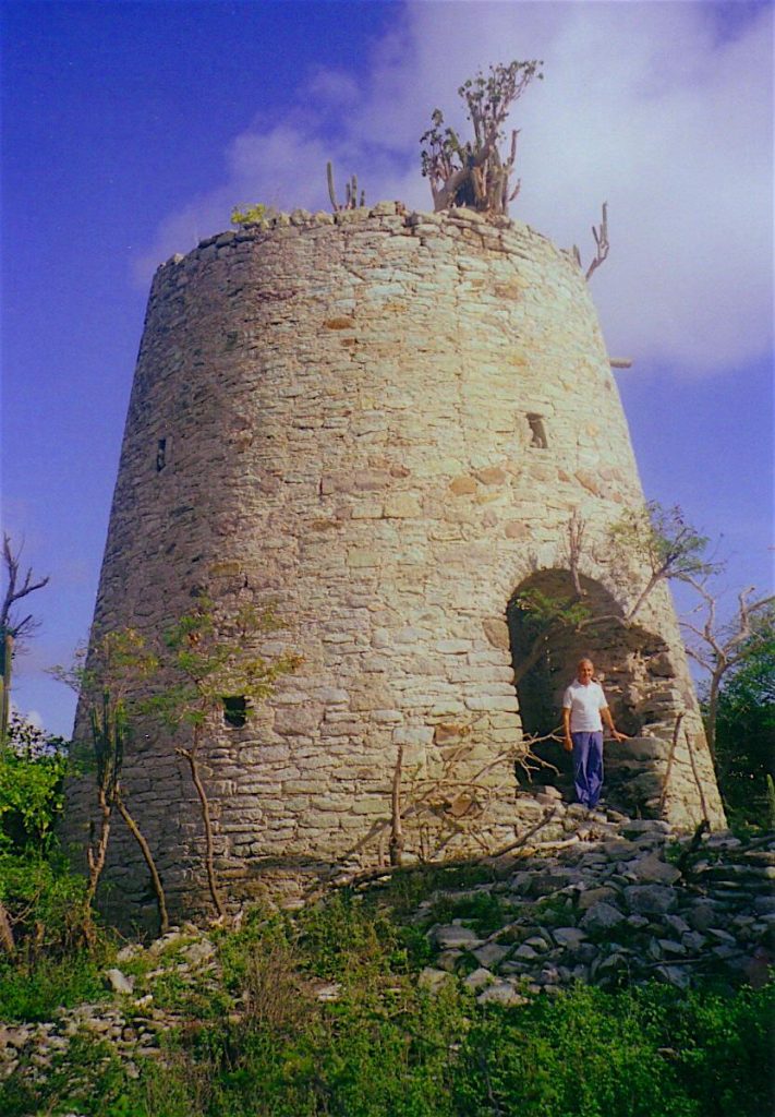
A lovely old mill sits on the hillside marking the site of this estate, built out of the indigenous green stone from the area. Nearby are two ponds which over the years have become choked with various water plants. It is also an old Arawak Indian site.
Estate Related History/Timeline
1667: “Nathaniel Monk 16 1/2 mens lands formerly belonging to Thomas Thompson Cooke.” There is a record of a succession of land acquisition by Nathaniel Monke as follows:
1668: 30 1/2 acres by Samuel Winthrop
1671: 40 acres by Col. Philip Warner
1676: 47 and 37 1/2 acres by Governor Warner
1678: 50 acres
1678: 37 1/2, 50 and 49 acres by Sir W. Stapleton
1678: Mrs. Nathaniel Monke sells 20 acres to Ed Williams.
1696: Nathaniel Monke Will 1696. “…… to my son Nathaniel Monke all my plantation near Falmouth after my wife’s death.” Vere Oliver Vol.II p.266
1679: “In 1679 an Act empowering Nathaniel Monk to sell the Plantation of Benjamin Steele and Mary his Wife for the Maintenance of their children.” Vere Oliver Vol.II p.267
“……and also all those 2 undivided 3rd parts now belonging to Stephen Lavington in fee simple of all that plantation called Monk’s Hill plantation containing 173 acres …. in the Parish of St. Paul and Division of Falmouth.” Vere Oliver Vol.II p.166.
Extensive walls and foundations in the area.
1758: “John Lightfoot – Will 1758. 3rd part of a plantation called Monk’s Hill and all that undivided 3rd part of a plantation in the parish of Willoughby Bay called ‘Roundhill.’” Vere Oliver Vol.II p.182
“In 1824 a Mr. Johnson was sent out to the West Indies by Mr. Gordon to ascertain the condition of family estates there. The report was very voluminous and illustrated with watercolor drawings, maps, plans, etc… the following figures are taken. He also owned Fairhall 421 acres and Brebner of 259 acres in St. Vincent.
In Antigua, Sanderson’s 311 acres – 230 cultivated. 61 men, 98 women, 82 boys and 74 girls. Total number of slaves: 315. Osborne’s 217 acres all pasture.
Lavington’s 185 acres of which 155 cultivated. 28 men, 44 women, 28 boys and 45 girls. Monks Hill 172 acres, all pasture.” Vere Oliver Vol.II
“On top of Monks Hill, was a large ball with lights around it. It could rise up through a scaffold up to several feet in the air. People could stay far away and see the moving ball. It would go up at 6 and 7 in the morning and at 12 noon, then at 4 in the afternoon and the last movement of the day was at 5’clock in the evening. It was the best guide to set some people to work and to break them off from work. We could stay at Belview Estate in the middle of the island and see the ball to up and down. Some English Planters use to spend their after crop holiday in the Great House on Monk’s Hill.” To Shoot Hard Labour 2 p.92
1923: This method of timekeeping ceased to be used in 1923
1950’s: The cisterns were used as late as the 1950‘s when Desmond Nicholson remembers the villagers trudging up the hill for a bucket of water in periods of severe drought.
Fort George, Monk’s Hill 1689-1850
Above Monk’s Hill estate on the crest of Monk’s Hill is an extensive military ruin over the whole of its eight acres, surrounded by a beautiful wall of greenstone quarried from the village of Liberta. It was here in 1689 that the English settlers established a large fort designed to defend Antigua’s first town and harbour, Falmouth and was a place of last refuge in case of invasion by the French. It also proved a stronghold and defense against the Carib Amerindian attacks that emanated from Dominica and St. Kitts and overlooks Falmouth and the Dockyard. Because it was a place of last refuge, large cisterns were built and these along with two powder magazines at either end are still in fairly good shape today. The entrance is situated through a narrow arch in the northeastern wall with a sentry box on either side on the wall above. The latter however are crumbling yet the arch remains (2000). A military cemetery is located on the outside of the wall, however, many of the grave stones have been removed and turned into glass topped coffee tables.
A development plan for this heritage site has been made in the UWI publication “Built Heritage Conservation Tourism Planning in Antigua: The Case of Fort George Monk Hill,” by Frederick D.G. Southwell, (1998) Dept. of Survey & Information; Engineering, UWI.
www.tombstones.bb (2005)- Visit site for Military burials near the Fort
Enslaved People’s History
Based on contemporary research, we have little information to share about the enslaved peoples from this plantation at this time. We will continue our quest for more information about these vital individuals.
Ownership Chronology
Ownership prior to Thomas Thompson Cooke
- 1667: Nathaniel Monke
- 1697: Nathaniel Monke & Mark Monke
- 1755: Stephen Lavington
- 1758: 3rd part John Lightfoot
- 1777: Fran Gordon – 1777/78 Luffman map
- 1800: James Gordon (1766-1807)