Type: Extant
Parish: St.Paul
Founding date: 1750
See on Google Maps!
Current Status
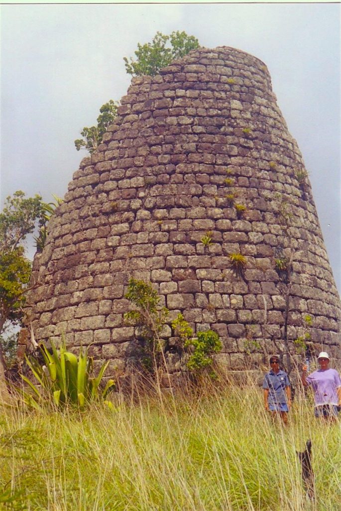
The mill at this site is made of volcanic stone blocks, larger at the base getting smaller towards the top and has deteriorated on the western side due to exposure to the weather. It stands on the brow of a hill and once viewed it is difficult to understand how sugarcane prospered under the full force of the trade winds. Below remains the ruins of the boiling house built of the same stone which are in excellent shape and which S. Walter had started to rebuild as a residence. The roof and anything built of wood has since deteriorated. Several coppers remain scattered on the hillside along with a few bits of machinery. This mill has to be hiked into which I last did in 2002 due to bush having completely taken over the road.
There is actually a foot path from the village of Liberta that traverses up and over Howard’s and down into Barter’s and Rendezvous Bay. With nearly everyone owning a car in these modern days, a lot of these old foot paths (have) are becoming extinct.
Estate Related History/Timeline
1811: Will of Maxwell late of Carriden, Esq., 10 September 1811. Caribbeana “… is witnessed that I granted to them (of the 3rd part) all that my Richmond plantation in the Parish of St Paul in the I. of Antigua also that other called Chapman’s and Howard’s Plantations with all slaves to hold upon trust to secure to my wife a joynture of 800 pounds per year …..”
1829: In 1829, this estate, combined with Richmond’s, contained 461 acres and 298 slaves.
1851: The Antigua Almanac shows Howard’s of 461 acres belonging to Mrs. N. Gilbert.
North of Howard’s on the 1935 Alex Camacho map there is an estate called ‘Brodies’ in the Parish of St. Paul. This is the estate known as Windy Hills, owned by Alexander Brodie, and is actually in St. Mary’s Parish, but straddles the border into St. Paul’s.
Enslaved People’s History
Based on contemporary research, we have little information to share about the enslaved peoples from this plantation at this time. We only know that, in 1829, this estate combined with Richmond’s, contained 461 acres and 298 enslaved peoples. We will continue our quest for more information about these vital individuals.
Legacies of British Slave-ownership: Richmond and Howards were awarded £4,525 7 s 8 d for 325 enslaved. Nathaniel Snell Chauncy was the awardee, Mr. Hon. Edward Ellice was noted as ‘other association’ and William Holden and William Maxwell MP were unsuccessful.
Ownership Chronology
Ownership from 1750 James Barter
- 1790: John Maxwell – 1777/78 Luffman map
- 1810: William Maxwell (d. 1811)
- 1843: Nathaniel Gilbert
- 1851: Mrs. N. Gilbert
- 1933: Chrystom E. James – 1933 Camacho map
- 1971: Selvyn Walter