About
Type: Extant
Parish: St.Peter
Founding date: 1750
See on Google Maps!
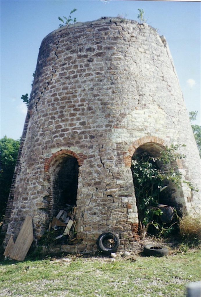
Current Status
The mill is in quite good condition but is surrounded by houses of the village. There is a copy of the original Estate plan showing the layout of the entire estate. The main road going from the triangle below Mt. Joy over to All Saints in known as Jonas Rd and the surrounding land has become residential.
Estate Related History/Timeline
1851: Antigua Almanac shows Jonas’s (A.S.) of 325 acres as belonging to Thomas L. Brooke.
1852: “Thomas Langford Brooke owned Langfords 404 acres in St. John’s Parish, Langfords Woods 280 acres St. John’s Parish, Jonas’s 325 acres St. Peter’s Parish and Laroche’s 231 acres St. Paul’s Parish. 10 years ago two other estates were sold, the whole of the Antigua property of about 1700 acres for £10,000 to Mr. Camacho, a Portuguese merchant in St. John.” Vere Oliver Vol.II p.151
In 1829, this estate contained 325 acres – 150 slaves.
In the colonial period, the Langford Brooke family of Mere in Cheshire, England, owned several properties on the island of Antigua. This map from 1821 shows the Jonas estate. The references at the right provide information about the shares of land devoted to growing sugar cane and to other uses, as well as a key to the plantation’s structures, which included the windmill, boiling house, curing house, rum cellar, the overseer’s rooms, the sick house and laying-in room, the great house and offices, and pens for mules and cattle. An accompanying ground plan, produced by the same surveyor, depicted the estate’s works and buildings in more detail. World Digital Library
Sammy Smith in “To Shoot Hard Labour” p.33
1877: “It was at Jonas estate in 1877 that Margarette gave birth to her first boy-child, the first man to arrive in the family since the root was pluck up from Africa and brought to the West Indies many generations ago. Happy-go-lucky, the name of the chief planter at Jonas back then was Samuel Smith. My mother and father name that first man pickney after him. Me, Samuel Smith, was that man. That is how, in the name of the Lord, I arrive on Monday, 1st January, New Year’s Day 1877 at Jonas estate to face the world and all it have to offer.”
“The Northern side of Freeman’s Ville was part of Jonas estate long ago. Jonas wasn’t a large estate, but was suppose to be one of the best on the island. It was cut in two by a stream that run off the hill of western All Saints and through Jonas down into the sea at Blackman’s Bay. Both sides of that stream was famous for the very rich sugar crop and for the plenty vegetables and fruits. It was indeed a rich place, but the ex-slaves had nothing. I was born there at Jonas, forty-three years after slavery end, and up to that time, the ex-slaves had nothing.”
***“A negga woman by the name of Missy Byam get raped by Massa Ted Cole, one of the English planters on the estate.” He then raped her 13 year old daughter Kate then threatened her and told her never to come back to Jonas because he was afraid of his wife’s wrath. Kate answered back and Cole let his dogs on her and in trying to escape fell into Work’s Pond. Everyone saw but none dared to help and Kate drowned with Massa Cole shouting out “Give the child to the man under there!”
1878: The other major new owner was A.J. Camacho, a Portuguese from Madeira who seems to have arrived somewhat later than the majority of Portuguese immigrants and to have begun almost immediately to acquire estates. By 1878 he owned two—Bellevue and Briggins—totaling a respectable 967 acres; by 1891 he also owned Langford/Mt.Pleasant/Dunbar’s, Otto’s, Wood’s, and Jonas’s, for another 2,000 acres. These latter were more scattered, but all were clustered close to St. John’s antiguahistory.net/upload
1933: The village of Freemansville was part of the Land Settlement Act.
1941: Antigua Sugar Factory, Ltd. Cane Returns for 1941 Crop. Jonas. Estimated 1403 tons, 112 acres estate – acres peasant land on the estate, tons of cane delivered 1294.
Enslaved People’s History
Based on contemporary research, we have little information to share about the enslaved peoples from this plantation at this time. We only know that the estate contained 325 acres and 150 enslaved people in 1829, 134 of whom were liberated for a sum of £1,935 13 s 13 d after slavery was abolished in the Caribbean. Unfortunately, we also have a painful story that’s been passed down since the old days of slavery on this estate: “A negga woman by the name of Missy Byam get raped by Massa Ted Cole, one of the English planters on the estate.” He then raped her 13 year old daughter Kate then threatened her and told her never to come back to Jonas because he was afraid of his wife’s wrath. Kate answered back and Cole let his dogs on her and in trying to escape fell into Work’s Pond. Everyone saw but none dared to help and Kate drowned with Massa Cole shouting out “Give the child to the man under there!” We will continue our quest for more information about these vital individuals.
Legacies of British Slave-ownership claimants: In 1833, Parliament finally abolished slavery in the British Caribbean, Mauritius and the Cape. The slave trade had been abolished in 1807 but it took another 26 years to effect the emancipation of the enslaved. The legislation of 1833 was the result of a combination of factors where it was felt that the plantation owners should be compensated for their slaves who were to be freed. The amount of 20 million pounds , a huge amount in those days, was divided up between all slave owners. Peter Langford Brooke – absentee/resident – awardee trustee – Antigua 308 (Jonas) view £1,935 13 s 3 d (134 enslaved). See also The Wood, Langford’s, La Roche’s.

Ownership Chronology
- Ownership from 1750 Jonas Langford Brook d.1784 left it to his grandson 1777/78 Luffman map
- 1820: Peter Langford Brooke (1739-1840) 150 slaves
- 1843: Thomas L. Brooke
- 1878: J.W.L. Brook (lsd.to T.B.Smith) 1872 Horsford Almanac
- 1891: Antonio Joseph Camacho (d.1894)
- 1894: John J. Camacho (d.1929)
- 1933: Government Land Settlement – Freemansville 1933 Camacho map
- 1968: Antigua Government – Crown Land