About
Type: Ruin
Parish: St.Philip
Founding date: 1698
See on Google Maps!
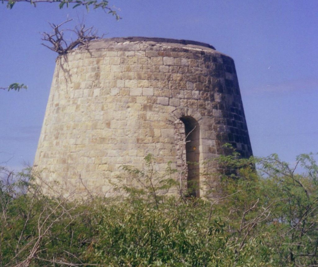
Current Status
A mill still exists and this estate which never converted to steam. The estate is situated off the Half Moon Bay road close to the turn off for the village of Freetown and is bounded in the south by the sea. Manning’s was one of nine estates purchased by the Antigua Distillery in order to produce molasses for the production of Cavalier Rum. There is another half mill on the left side of the road which does not show up on the 1729 Moll map which Mr. Edwards of Freetown said also belonged to Sheriff’s which adjoins Mannings. Before the road was widened in recent years, part of the works wall was visible right next to the road, but was obviously knocked down during road works. Sheriff’s in 1933 is shown as belonging to the Heirs of J.A. DeSouza.
Estate Related History/Timeline
A rather interesting letter is recorded in a medical journal from Dr. Thomas Guillen to Dr. Duncan in 1791. “On the 25th of June laft, I was called to vifit a negro girl about fourteen yearf of age, the property of Charlef Manning, Esq. I found her very much emaciated complaining of flying pains in the cheft, with a quick pulfe, and a flight degree of fever, attended with a confiderable at the heart, than I had ever obferved. Fhe had no appetite for food, or even drink. Fhe complained of great vertigo, which I imagened, and proceeded more from general debility, than any other caufe.” The story continues, “Feveral different medicinef were tried, by my advice, as well af that of Dr. Samuel Athill, who alfo vifited her. But her ftrength continueing to decline, fhe died on 29th June.” He goes on to say that he opened up the body to discern the cause of death the day afterwards and found naught but an enlarged heart. However, on discecting the heart he found the ventricles preternaturally small and with a considerable quantity of white soft matter which had the appearance of fat.
William Manning was a West India merchant and landowner in St. Kitts, MP for Lymington 1801-1818, Eyesham 1806-1818 and Penryn 1825-1830, leading voice in the West India lobby. He headed the leading house of Manning’s and Anderdon.
In 1829 this Estate contained 173 acres – 68 slaves.
Manning’s & Anderdon in the 1840’s were prominent merchant consignees. They owned Duer’s and was the agent for the Tollemach estates, but by 1852 seem to have withdrawn. (Susan Loews)
In 1823 William Manning’s partners were his son-in-law John Lavicount Anderdon and his eldest son Fredrick Manning. By 1821 the price of sugar had fallen 2/3rds and the firm declared bankruptcy. The chief creditors were the brokers Kemble & Son of Mincing Lane, on whose behalf the commissioners discovered considerable assets including property in Antigua, Montserrat, St. Kitts, Nevis, Trinidad and St. Croix. See History of Parliament Research.
1833: The Laws of the Island of Antigua No.114 states that the provost marshal for want of goods and chattels of the said parties respectively proceeded to levy upon the said plantations or estates, vix., that sugar plantation called “Manning’s” containing two hundred and one acres of land situate in the division of Nonsuch and parish of Saint Philip, the property of William Eales Ledeatt, charge with the sum of two hundred and thirty-six pounds and five shillings, amount of instalment and interest up to the first day of May last past, and with the remaining principal sum of nine hundred and eighty-eight pounds and fifteen shillings payable as in the said herein-before mentioned Act is set forth, also …”
Ledeatt Cove Cove(s) is drawn on the Nationala Geospatial Agency (NGA) Map. Ledeatt Cove is located in the Saint Philip Area of the Country of Antigua and Barbuda. The Cove(s) is located at the latitude and longitude coordinates of 17.083333 and -61.683333. Fishing enthusiasts interested in fishing near or at Ledeatt Cove should print out the Google map and take it with them on their fishing trip. This could be one of the best fishing or outdoors adventure locations in the regions of Americas/Western Europe.
On the north side of Nonsuch Bay is a small, well protected anchorage called Ledeatt Cove but is is only suitable for 2 or 3 yachts at a time and of 2.3 metre draft or less. Antigua & Barbuda Marine Association.
Charles Manning, son of William, under the marriage settlement of Bethel Walrond and Lady Janet St. Clair and as such awarded compensation for Upper & Lower Walrond and Little Duer’s, Antigua. T71/877 Antigua clam No.79.
1851: The Antigua Almanac shows Manning’s of 173 acres belonging to W.E. Ledeat.
1852: In 1852 “Mannings” of 173 acres was owned by W.E. Ledeatt. John and Esther Ledeatt had two daughters and one son, William Eales Ledeatt. Just as John’s youngest son from his first marriage, Charles Manning Ledeatt, had become the heir to Charles Manning Esq., so William Eales Ledeatt, the youngest son of his second marriage, also inherited a plantation of 173 acres known as Manning’s.
William Eales Ledeatt, Member of the Assembly, married Eliza Sedgewick in 1818. When William was appointed Captain of Fort James, it seems that the family moved into the Fort where it had been the custom for the Captain to receive a fee of 18s. from each passing vessel, and if the fee was not forthcoming, a swift reminder would be fired across the bow of the ship from one of the cannon on the ramparts, many of which are still there today. The lived there till the hurricane of 1872 when they were forced to move out because “there was not a room in it habitable.” They then moved into St. John’s close to their daughter Georgina, one of eight children. The Ledeatts of Antigua (Nugents of Antigua)
1930‘s: Mr. David Edwards of Freetown (2015 age 92) remembers that he got hand-me-downs from the son of the manager, Walter Mathew. His grandmother sewed for Annie, Mr. Mathew’s wife and she would alter them to fit. Mr. Mathew, who was the manager of Manning’s, died and the sons went away, just the baby moved with the mother down by Barnes Funeral Home somewhere and they lost touch.
The buff house was of pitch pine and Eddy Lake from Comfort Hall employed people to stay at the house. People from Willikies came to harvest the cane which was taken to the Bristol Line at Gaynors for transport to the sugar factory. Everything finally went into disrepair and there is nothing much left now except for the mill tower.
DeSouza Road is located next to St. James S. Club Villas and is 0.66 kilometers.
In 1944 Manning’s became part of the Antigua Distillery holdings aligned with Montpelier Sugar Factory.
Enslaved People’s History
Based on contemporary research, we have little information to share about the enslaved peoples from this plantation at this time. We do know that Lyon’s was awarded £4,236 3 s 7 d for 274 enslaved peoples’ freedoms after slavery was abolished in England. Despite these limitations, we will continue our quest for more information about these vital individuals.
Ownership Chronology
- 1716: Moll map shows ‘Lynch’ in this area
- Prior William Manning
- 1790: Charles J. Manning (1777-1835) 1777/78 Luffman map
- 1820: George Wickham Washington Ledeatt. Passed to his family from Charles Manning owner in fee. Will 1790.
- 1829: William Eales Ledeatt. Md. Eliza Sedgewick 1818. 173 acres, 68 slaves.
- 1851: W.E. Ledeatt. – 173 acres 1851 Antigua Almanac.
- 1872: William Parker – 200 acres 1872 Antigua Horsford Almanac.
- 1878: John F. Foote. Bapt. 1851 and still living in 1893. Planter
- 1929: J.A. DeSouza
- 1933: Mrs. J. A. DeSouza 1933 Camacho map
- 1944: The Antigua Distillery (Montpelier).