About
Type: Ruin
Parish: St.Philip
Founding date: 1750
See on Google Maps!
Current Status
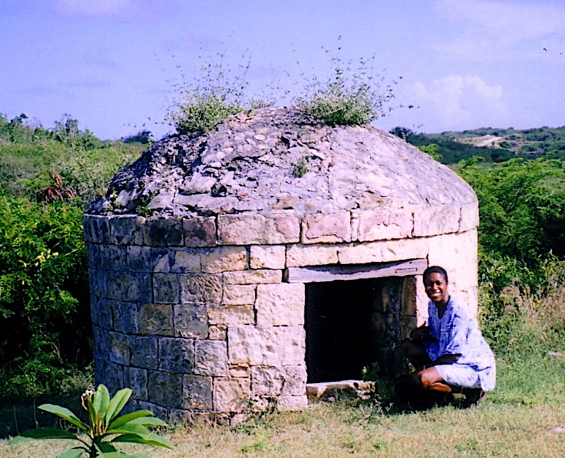
There is no longer a mill at this site but a very interesting domed stone structure remains on the grounds that was used to intern errant slaves, known as the slave dungeon. There were apparently two, because in 1871 a hurricane blew down one of the two old slave dungeons. The estate house has been remodeled over the years, but one can still see some of the old existing walls. Near the sea to the north of the house almost in the mangroves can be found more ruins of the works. The entire area where the buff and slave dungeon are is now residential.
Estate Related History/Timeline
Sammy Smith in “To Shoot Hard Labour p. 106, says “Between the villages of Willikies and Seatons was the famous Parson Maules Estate that was surrounded by Grand and Dundan plantations. The few French families that didn’t leave Antigua after the French give up the land use to live at Parson Mauls and around there. I hear a lot of Arawaks use to live around there too. The Goodwin family use to have a lot of ancient tools and other things that was found there.”
“The slave massas at Parson Maules was like the others, full of rage at the slave rebellion in 1736. The slaves saw living hell for the Parson Maules bakkra have two dungeions, the Torturer and the Bump-off. Old George Goodwin use to say that Parson Maules have more suicide than any other estates.”
1829: In 1829 this Estate, combined with Collins, contained 179 acres—152 slaves.
1851: The Antigua Almanac shows Parson Maules, or 179 acres belonging to George W. W. Ledeatt.
1852: In 1852 Parson’s Maul of 179 acres was then owned by Geo. . W. Ledeatt who also owned Mannings of 173 acres.
1921: In 1921 165 acres.
“Esther Wickham (d.1801) owned Parson Maule’s in Antigua.”
“George Wickham Washington Ledeatt (d.1808) owned Parson Mawue’s”
Mr. Seafridge Coates owner of Parsons Maule (Parsmall) Estate near Seatons had five (5) children with Diana – they were not married. Margaret Adelaide Coates, Arthurly (?) Coates, Fanny Coates, Jack Coates and Lav (?) Coates.
“After Seafridge Coates died, Diana was moved to a small house on the estate. Mr. Coates sisters, who lived in Newgate Street, went back to the estate and sold all his belongings leaving Diana with nothing. Diana had one last child, Joyce with another man with whom she became involved with to help her support her other children. Mr Coates had bought a plot in St. Stephens Anglican Cemetery for himself and Diana to be buried side by side. When Diana died she was buried in a pauper’s grave as his sisters made sure she was not buried in it. Someone else was buried in her plot.”
Family history, Desire Edwards.
This had to be mid 1800‘s
1941: Antigua Sugar Factory Ltd Cane Returns for 1941 Crop. Parson Maules. Estimated 541 tons, 50 acre estate, ? acres peasants on the estate, tons of cane delivered 310.
Enslaved People’s History
Based on contemporary research, we have little information to share about the enslaved peoples from this plantation at this time. What we do have is disturbing. While the estate was only awarded £398 3s 7d for the liberation of 24 enslaved people in 1829, a quote from a former slave in the area rings clear: “The slave massas at Parson Maules was like the others, full of rage at the slave rebellion in 1736. The slaves saw living hell for the Parson Maules bakkra have two dungeions, the Torturer and the Bump-off. Old George Goodwin use to say that Parson Maules have more suicide than any other estates.” George W. Ledeatt was the awardee, unsuccessful were Hardman Earle, Rev. Robert Hesketh and John Hayward James. We will continue our quest for more information about these vital individuals.
Ownership Chronology
Ownership from 1750 Samuel Lavicount
- 1790: John D.. Halliday
- 1800: Esther Wickham d.1801
- 1801: George L. Ledeatt – 152 slaves in 1829
- 1851: George W. W. Ledeatt d.1808 1851 Antigua Horsford Almanac
- 1872: Edward Becket – 89 acres
- 1800c: Seafridge Coates
- 1878: Edward Becket 1872 Horsford Almanac
- 1891: I. Desouza
- 1921: A. Edwards
- 1933: Jardine & H.D. DeSouza 1933 Camacho map.
- 1950’s: Isaac Hawkins b.1902
- 2000: Heirs of Hawkins
- Present day the buff and surrounding land, Jack Patterson