About
Type: Extant
Parish: St.John
Founding date: 1678
See on Google Maps!
Current Status
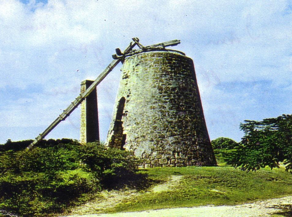
The former plantation site is littered with the remaining foundations of old buildings and abandoned and broken machine parts from the original sugar mill, which somehow escaped the World War II steel reclamation program. The mill was converted from wind power to steam in the 1800’s. The chimney is in excellent shape even today.
Estate Related History/Timeline
This plantation started in 1678 with 250 acres of land, expanded to 514 acres by 1829, and then began to shrink; in 1921, it comprised only 460 acres. The decline was undoubtedly the result of the higher cost of labor after the British Parliament abolished slavery in 1833 and the decline of Antigua’s sugar business in the late 1800’s and early 1900’s.
Although best known as the Union, the 1777/78 map by cartographer John Luffman identifies it as “Weekes,” presumably in recognition of the owner, John Weekes, who died in 1738. The estate was originally known as “Haddon’s” because it was owned by Richard Haddon and then his son, Dr. John Haddon, who left it to Mr. Weekes. The first mention of the name “Union” appears in Vere Oliver’s second volume of Antigua’s history, where he notes that Langford Lovell Hodge (b. 1807) owned the Cook’s (#26), Union (#27) and Hodge’s Bay (#4) estates. Today, the area continues to be called “Hattons”, a derivative of “Haddons”.
“He was able to place my mother and family at Hatton Estate. Hatton and Grays abutted and bounded on the west. There they stayed for some weeks until the Manager and my grandfather fell out. I was told that they could not see horse at all (eye to eye) and so the family had to leave.”
Keithlyn Smith on Aunt Dood in Symbol of Courage.
In 1772, the estate was indentured “between Thomas Turner Wise (son of John Wise), William Livingston and the Honorable Francis Farley, witness that in consideration of 5 shillings paid to Wise and Livingston grant to Francis Farley all that plantation, late of John Wise, containing 156 acres and dwelling house and all slaves, horned cattle and living stock for one whole year that Francis Farley may be in actual possession.”
Vere Oliver, Volume III.
Francis Farley of Farley Bay, Antigua, has been the subject of DNA research as part of the Sauratown Project by Professor Charles D. Rodenbough in North Carolina. Professor Rodenbough is using DNA to trace the 100 slaves from Cameroon who worked on Farley’s Antigua plantation. He subsequently relocated them to his tobacco plantation in Virginia and his cotton plantation in North Carolina.
John Duer Cranstoun was manager of both The Union and Cook’s estates in the early 1800s, and his family went on to own Potter’s (#47), Cochrane’s (#83), and Thomas’s (#138).
In 2009, the works for crushing sugar cane could still be seen. They were one of only three remaining sets on the island, one of the others being at Betty’s Hope, which was completely refurbished as a working showcase of the old plantations. The works at Betty’s Hope actually came from the Thibou Jarvis sugar mill (#34) and were donated by the Shoul family.
In the early 1940s, most scrap iron in Antigua was shipped to the U.K. to aid the World War II military effort, and this included all of the millworks no longer in use, with the exception of this mill and a few others. The mill at The Union is crumbling rapidly. However, the brick chimney from the days when the estate converted the mill to steam is still in excellent shape. This mill was one of the last to operate, not decommissioned until the 1920s. The ruins of the estate house also are visible further down the hill.
The mill was so damaged by 2013 that it was partially knocked down to remove the iron works inside. The police launched an investigation to determine if the mill had been demolished by someone anxious to steal the ironworks for salvage. Tyre Master, who had removed the works, publicly stated he would construct a Museum at the Antigua Sugar Factory, open for public viewing. That has not yet happened (2016).
George Martin says there was a stone marker on the estate where slaves were hung (also see Denfield’s, #25), but it cannot be located.
In 1941, the Antigua Sugar Factory, Ltd. estimated cane returns from The Union estate at 100 tons from 98 tons of cane delivered and 0 peasants’ land on the estate.
Enslaved People’s History
Based on contemporary research, we have little information to share about the enslaved peoples from this plantation at this time. They probably had a maximum of 208 people working at that plantation. A fact of interest is that Francis Farley of Farley Bay, Antigua, has been the subject of DNA research as part of the Sauratown Project by Professor Charles D. Rodenbough in North Carolina. Professor Rodenbough is using DNA to trace the 100 slaves from Cameroon who worked on Farley’s Antigua plantation. He subsequently relocated them to his tobacco plantation in Virginia and his cotton plantation in North Carolina. Also, George Martin, the owner since 2000, says there was a stone marker on the estate where slaves were hung (also see Denfield’s, #25), but it cannot be located. We will continue our quest for more information about these vital individuals.
Ownership Chronology
- 1678: Captain John Haddon granted 274 acres. d. 1723. Passed 250 acres to Dr. John Haddon (1690-1738)
- 1678: Richard Haddon granted 250 acres
- 1738: John Weekes, Esq., d.1738. Bequeathed his estate to James Nibbs of Popeshead
- 1738: James Nibbs d.1751.
- 1751: Jonas Ian Nibbs
- 1777: James Langford Nibbs Baptized 1738; d. 1795 (1777/78 map by cartographer John Luffman.)
- 1792: James Langford Nibbs Baptized 1738; d. 1795
- 1817: James Lovell Hodge 1817
- 1829: Heirs of Langford Lovell Hodge b. 1807. 514 acres, 208 slaves.
- 1843: Heirs of Hodge
- 1872: Robert Dobson, 483 acres.
- 1891: Robert Dobson
- 1921: F. December 460 acres.
- 1933: Mrs. M. T.Camacho (1933 Camacho map.)
- 1940’s: John I. Martin
- 2000: George Martin