About
Type: Extant
Parish: St.Peter
Founding date: 1647
See on Google Maps!
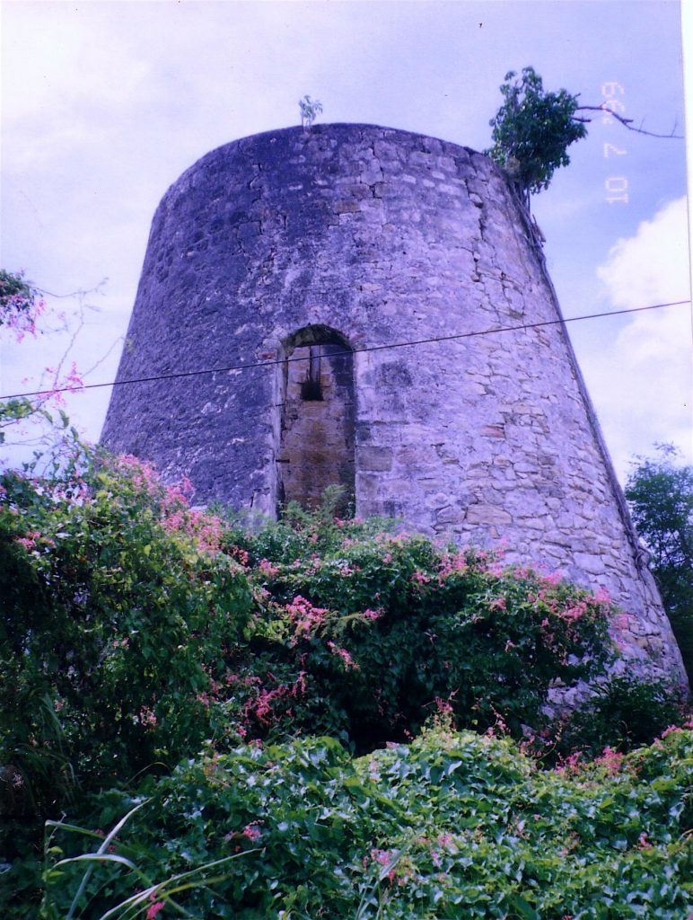
Current Status
From various records it appears that “Wakering Hall” was assimilated into the Vernon’s overall estate when Dorothy Everard’s mother, Elizabeth, married John Vernon. This mill is in excellent shape and remains of the steps to the great house have been incorporated into a garden by residents below, whilst the ruins of the house on the hill above has been completely taken over by the bush. Nearby to the east of Vernon’s hill is a small walled Anglican cemetery in which are interred owners of various estates nearby including members of the Foote family, manager of Parham Hill. Jack Foote was Headmaster of the Boys Grammar School in the 50’s. This estate converted to steam in the mid 1800’s and in 1864 contained 400 acres.
Vernons was put up for sale in the Court of the Commissioners for the Sale of Encumbered Estates in 1863, particulars of which in various flyers are copied below. On the page showing Vernon’s Island in Parham Harbour, a red line delineates the land belonging to the estate, most of which is in mangroves and swampy land. There also appears to be a small building and a spring in the center of the island. However, it also shows higher land on either side of the High road and a Wesleyan Burial ground nearer the sea which would be what is now known as the Tyrrel hill. In speaking to Mrs. Tyrell who came to Antigua in 1950c when the Cadastral Survey came to Antigua to sort out the Syndicate land being taken over by the Antiguan Government, the land was classified as Vernon’s land with the exception of where her daughter’s house stood just south, which was known as Twenty Hill. The whole hill had the reputation of being haunted with many a confirmed sightings of Jack-o-lanterns, but it also stemmed from the graves that were found on the hill below the swimming pool to the north. The map also shows a “spring pond” which what appears to be a connection to a cistern and nearby several buildings. Another map shows Vernon’s buff and surrounding buildings which include the mill and works as well as “The Negro Houses” of which there are over 100. It is likely, as Vernon’s was centrally located among the Tudway estates, that all of the workers lived in that one area.
Lynsey Hill is directly east of Vernons and was part of the Tudway estates. In the 1930’s the manager was a Dr. Edwards and anyone working on the estates who became ill, were sent up to Lynsey Hill. Parham New Works has also been called Lynsey which is across the road from the village Pares.
Estate Related History/Timeline
1664: Vernon’s was a grant made in 1664/65 by Lord Willoughby of Parham and Sir W. Stapleton, Capt. General of the Leeward Is. , to Col. John Vernon, an officer in the Royalist Army. Oliver Vol.III p.176
1668: Clement Everard, Gent., jun., 160 acres at Popeshead. (Book of Claims)
Col. Clement Everard, an owner of estates in the Leeward Isles named in a petition of St. Kitt’s inhabitants. In 1659, twelve articles of complaint were drawn up against Col. Clement Everard, the Deputy Governor of St. Christopher’s, but the petition and sentence have been lost. (Calendar of Colonial Papers 1574-1666)
1662: Will Thomas Everard of Antigua, Gent. d.1663. Will dated 31 January 1662 Owned the “Wakering Hall” Plantation in Antigua.”
1662: Dorothy Everard 1st daughter under 18 in 1662, owned half of 380 acres in 1672 in her own right, which she conveyed by Act of 1678 to her step father John Vernon, mar. George Symes in or before 1679 when “Wakering Hall” was settled on them.
1670: “Col. Clement Everard, an owner of estates in the Leeward Isles, named a petition of St. Kitts inhabitants. In June 1672, he was a member of Council of St. Christopher’s. It was stated in 1673 that his estate had been devastated by the French since the notice of the Peace.” Vere Oliver Vol.III p.175
1672: “John Vernon and Elizabeth his wife, on behalf of Dorothy Everard, of the one part, and George Towes of Antigua, of the other, lease 20 acres, part of 380 acres.” Vere Oliver Vol.III p.176
1673: “Mr. John Vernon, 60 acres at Old North Sound by the Governor.”
1677: Capt. John Vernon, 260 acres. The first warrant 1674 by Governor Warner was for 60 acres, and the second by Governor Williams 1675 for 100 acres and the third 1677 for 100 acres by Governor Warner ….”
1678: Petition by Dorothy Everard, in part, by Maj. Wlm. Barnes and John Parry Esq., her guardians: “….. my sister dead, my mother married Capt. John Vernon. My father died 15 years ago His plantation ruined by the French, my father-in-law resettled and my share of 190 acres I wish to convey to him for 10 negroes.”
1679: John Vernon Gent., conveyed to George Symes and Dorothy his wife …. a plantation in Old North Sound called “Wakering Hall”. Lieut. George Symms is awarded 260 acres by Sir. W. Stapleton in 1681. 1717 there was an Act to enable Arthur Freeman and Dorothy, his wife, to sell and convey a certain plantation within the said island, to raise portions and make Provisions for Henry Symms and Elizabeth Atley, children of the said Dorothy by her former husband George Symms.
(Great & Little Wakering are adjoining parishes in the Hundred of Rockford, co. Essex)
1679: “Wakering Hall”, John Vernon of Old North Sound, Gent., of the one part and George Symms, merchant …. in consideration of a marriage lately had between George Symms and Dorothy his wife, John Vernon gives to them and their heirs a plantation called “Wakering Hall” in Old North Sound.” Vere Oliver Vol.III p.115
1681: Lieut. George Symes 260 acres by Sir. W. Stapleton.
1684: Henry Symes, Gent, 65 acres by Sir Wlm. Stapleton.
1724: “John Vernon of “Vernon’s” b.1650 d.1705. His estate was dis-entailed by Act of 1724 on the petition of Wlm. Moore and his wife.”
1822: A map of the Estate of Capt. John Vernon in Old North Sound Division and St. Peter’s Parish surveyed in 1822 by F. Baker, Surveyor in General
Cane pieces 285 acres – 3 Roods – 9 Poles
In Pasture 105 acres – 3 Roods – 14 Poles
The Island 24 acres – 2 Roods – 14 Poles.
V. Oliver Vol.III p.176.
In 1829, Vernon’s contained 416 acres and 368 slaves.
Copy of the will of John Joseph James Vernon 1823.
From: Record Office <Record.Office@lancashire.gov.uk>
31 January, 1785. Lease of John Vernon of Preston and Justinian Casamajor of High Canons, Shenley, Hertford, Esq. for an annual rent of 1500 pounds sterling for fourteen years and a further fourteen years at 1350 pounds sterling.
“A Plantation in the parish of Saint Peter’s, in the division of New North Sound, Antigua, (400 acres). Bounded on the East by High Road being the North-South Line, West by land of Edward Byam Esq., North by the harbour of the town of Parham and South by land of the late John Wickham, Esq.
Includes a dwelling house, wind mill, boiling house, curing house, still house, plus sugar copper stills, still heads, worms, stone worm tubs, (it was noted that by 1784 Justinian Casamajor had replaced the wooden worm tubs of 1771 by stone tubs), carts, carriages, and all Negro, Mulatto slaves, cattle, horses, asses and mules, plus the issue of the female slaves and the cattle to be born, timber and trees allowed to be cut down and carried away and rights to all watercourses and ways.”
A detailed inventory was performed by 5 inhabitants of the island in 1755 – Longford Lovell, Elias Ferris, James Richards, (Mand) Esquires, John Hall. This was to be updated. The Lease also covers extensive conditions such as replacement of slaves due to illness or death, if the island was invaded or if there was a rebellion or insurrection.
The plantation deed that he referred to (Ref: DP 513/1) was purchased as an individual document. While it may be possible to learn more about the family using our collections, this information is not readily available and so some research would need to be undertaken. Some of this material can be easily located in our catalogue, such as the will of John Joseph James Vernon, the plantation owner (WCW Jun 1837), however locating him in other records, such as parish registers, would require a more extensive search.
1835: Justinian Vernon (d.1842) assumed the name and arms of Cassamajor by the will of his grandfather Justinian Casamajor.
Indenture 1835 – “… all that plantation in the Parish of St. Peter and division of New North Sound, containing 400 acres. Vere Oliver Vol.III p.175
Colonial Office and Predecessors: West Indian Encumbered Estates Commission. information from The National Archives – Colonial Office (UK)
1804-1834 Ref.#CO 441/6/3
1835-37 Ref.#CO 441/6/4
1794-1892 Ref.#CO 441/5/2
1838-1862 Ref.#CO 441/6/5
1835-1868 Ref.#CO 441/6/1
1851: The Antigua Almanac show Vernon’s of 120 acres belonging to Major Vernon.
1857: There was a massive fire at Vernon’s which took the efforts of many volunteers in the area to control the fire and put it out. Cedar Hill, Fitche’s Creek and St John’s fire engines and the police were on the scene. 229 labourers pitched in from Parham Hill, Cedar Hill, Cochran’s, New Works and Parham, George W. Morrison rode on horseback from Vernon’s to Sanderson’s to recruit 26 Portuguese and the carters of Vernon’s worked ceasely throughout the night hauling water. Mr. Byam of Cedar Hill who owned the property, was profuse in his thanks for the communal effort.
1859: John Vernon of Vernon’s died 1859.
Slingsby Bethel was the chief agent and manager of all Antiguan plantations of his brother-in-law, Sir William Codrington. He died in 1758 leaving most of his fortune, including his real estate in Antigua, to his Codrington nephews. He returned to England 1730c and set up as a London Merchant. He was sending ‘great quantities’ of English woolens to the Guinea coast, purchasing there negroes for the British plantations and receiving in exchange ‘the produce of the islands, particularly cotton’.”
1865, August 9th: Vernon’s of 444 acres was advertised for sale by auction. Copies of the advertisement for this sale, flyer, terms of sale, particulars, maps and plans appeared for sale on Ebay for $750 US in September of 2014. Copies of these taken off the internet are attached. The estate at the time was owned by Herbert Mayo who agreed to upkeep the estate until all transactions for the property had taken place. The sale included Vernon’s Island, swamp land and mangrove situated in Parham harbour. This map shows a spring in the middle of the island and a watch house to the north. The map showing the layout of the buff house, mill and works, shows a very large settlement of negro houses to the north east, while another partial map shows Guinea Corn Hill where the estate abuts Parham Old Works. I could not find mention of the Vernon’s cemetery but note a small square area of Guinea Corn Hill.
Land included in the sale was 227 acres of Cane Land, 162 acres in Pasture & Intervals, 24 acres of Vernon’s Island and 29 acres of Land overflowed by the Sea at high water mark. The buildings consisted of a Dwelling-house, Windmill, and the other buildings used for the cultivation of a Sugar Estate. The fixed and unfixed machinery, implements, and live and dead stock are included in the sale. The live Stock upon the Estate as of April, 1865, consisted of – 2 Horses, 10 Mules, 23 Oxen, 1 Bull, 4 Steers, 3 B. Calves, 1 Heifer and 4 C. Calves.
1865: Vernon’s came up for sale in the Court of the commissioners for Sale of Encumbered Estates in the West Indies (Antigua. In the Matter of the Estate of John Vernon (dec.) and Justinian Vernon (dec,) Owners and Ex parte Herbert Mayo Petitioner. The sale was held on Wednesday, the 9th day of August, 1865 and included 444 acres. Particulars are shown in the attached papers advertising the sale, compliments of Mr. S. Partain who holds these documents.
1909: Vernon’s was added to Parham Old Works when the Tudways purchased the estate around 1909.
1944: The purchase price of all of the Tudway estates by Syndicate was £43,741.
1945: The Syndicate Estates, Ltd. divided their estates into Group A, B & C for easier management and in each group appointed a Superintendent, a Manager and one or two Overseers. In 1945, F.J. Goodwin was the Superintendent of both Tudways and Morris Looby’s. In 1953 Mr. W.H. Odlum who was the manager for various estates since 1937 and Tudway estates since 1945, died in 1953. In 1954 Group B the Superintendent was E.G. Derrick, included Tudways, Diamond (#87), Gilberts (#80), Comfort Hall (#103) and Betty’s Hope (#77) for a total of 857.0 acres.
In 1951, a number of house lots were sold to people who had been living on the land for some time, some of whom had rented, ranging in price from £45 to $545 for lots between 4 acres and 3,756 sq.ft.
1951: It was decided by the Syndicate Estates that Vernon’s Island could be sold to Ivan Wiltshire for £150, if not, to the highest bidder. 21.662 acres belonging to Tudway estates. 1951 was a very bad year for cane fires. Many set on purpose under agreement with the Union that the fields were too difficult to cut. Lavington’s 14 acres, Morris Looby’s 33 acres, Delap’s 491 acres, Burke’s 18 ¼, Tudways 31 ¾, Gilbert’s 9, Diamond none, North Sound 15 ¾, Fitche’s Creek 25, Cassandra Gardens 26 ½, Jolly Hill none.
Barbara Arundell will vouch for the 43 steps that lead up to the front of Vernon’s estate house. She grew up there and remembers running up and down counting as she went. There was a road that went round to the back of the house, but anyone visiting was expected to arrive by the front door and mount those steps.
An interesting small and old walled cemetery lies on the flat land to the east of Vernon’s, owned by the Anglican Church. Burial ground, among others, for the Foote family who lived and managed nearby at Parham Hill. It is however totally overgrown and very difficult to access (2008). Behind the cemetery is a lovely good sized pond known as Church Pond.
Rupert ‘Myson’ James (b.1929) of Parham lived at Vernon’s estate at one time and when asked what sports he played, he replied that growing up he really didn’t have time for sports.
Granted he played a little cricket with the fellas, spun tops during top season, flew kites during kite season, but as a boy he was kept busy. Cocks were their time piece then, and at first crow he would be up to go the two and a-half miles to Coconut Hall. He and a friend kept each other company, but come time to come home they didn’t always leave at the same time so they had a signal at a certain spot – if the tree branch was broken the other one had gone past, if not, you could either wait or break a branch yourself and head out. Before school he would have to move the cattle and in the evening tie up the calves so there would be milk in the morning, and he would have to cart water. He was responsible to keep the drum at the back of the house full and it took many trips with a bucket, walking, to fill that drum.
Wallings Dam served a lot of villages, but when the standpipe ran dry, and you could tell when the water turned red from the old pipes, then he would have to go to the nearby ponds, including Church Pond. That turned green one year and went down so far you could see all the eels at the bottom which the people would eat. When things were really bad he would go to the well at North Sound which was fed by a spring, but water used to be tight all round.
In 1946 a Foote died in England and she was brought back to Antigua for burial. She was the last person to be buried in the cemetery by Church Pond. The Foote family lived in the buff at Parham HIll.
Village Memories – The Precision Center
The buff was later lived in by a succession of Syndicate overseers and their families until the 1970’s and was then rented. There was a shortage of houses available for rent on the island in those days and Vernon’s was in a good location, close to St. John’s.
Enslaved People’s History
Based on contemporary research, we have little information to share about the enslaved peoples from this plantation at this time. We only know that the estate contained 416 acres and 368 enslaved people in 1829, and it was awarded £4,906 5 s 5 d for the liberation of 329 of those people later that same year. However, we will continue our quest for more information about these vital individuals.
Legacies of the British Slave-ownership: Antigua 324 Vernon’s was awarded £4,906 5 s 5 d for 329 enslaved.
Awardees were William Augustus Johnson, Rev. Henry Kirby, Ref. John Kirby, Charles Henry Strode, James Cranbourne Strode and John Vernon. Unsuccessful were Joseph Vernon and Rev. William Vernon.
Ownership Chronology
- 1647: Col. Clement Everard
- 1660: Thomas Everard d.1661
- 1662: Dorothy Everard (Everett) (1662 underage) (1657-1724) md. Capt. George Symms (1667c-1723)
- 1679: George Symmes & his wife Dorothy
- 1680c: John Vernon (1610-1689)
- 1689: John Vernon (1650-1705
- 1705: John Vernon (1696-1765)
- 1765: James Vernon (1744-1769)
- 1769: Maj. John Vernon (1773-1859)
- 1777: Lt. J. Vernon Esq. 1777/78 Luffman map
- 1815: John Joseph James Vernon (died 1823) of Whitehall, Lancaster.
- 1823: Justinian Vernon (d.1842) assumed the name and arms of Cassamajor by will of his grandfather Justinian Casamajor.
- 1835: William Byam
- 1851: Major Vernon
- 1855: John Vernon d.1859
- 1865: Vernon’s of 444 acres advertised for sale by auction by Justinian Vernon and petitioned by Herbert Mayo.
- 1871: Hubert Mayo 1872 Horsford Almanac
- 1878: Heirs of Hubert Mayo Showed 186 acres in the Encumbered Estates Court
- 1909: Commander L.P.C. Tudway 1933 Camacho map. Added to Parham Old Works
- 1950’s: Cosmos Philip
- 1958: The Antigua Syndicate Estates, Ltd.
- 1968: The Antigua Government – Crown Land